

OpenSite Designer CONNECT Edition 2022 Release 1

OpenSite Designer CONNECT Edition 2022 Release 1 | 7.7 Gb
The Bentley Systems team is pleased to announce the availability of OpenSite Designer Connect Edition 2022 Release 1 (10.11.00.115) is integrated application for civil site and land development workflows across conceptual, preliminary, and detailed design phases.
OpenSite Designer 2022 R1 (10.11.00.115) what's new
This release is considered a “major” version:
- Data created with 2022 R 1 will need to be downgraded in order to be opened with a previous release.
- It can be installed side-by-side with previous versions.
This section provides a list of new features in Bentley OpenSite, OpenRoads, and OpenRail Designer CONNECT Edition products, also referred to as OpenX Designer products. Features that are only available in specific products are appropriately noted as such.
General Enhancements
- Update of Power Platform to Edition (V10.17.00.990).
- Subscription Entitlement Service (formerly CONNECT Licensing) is utilized. For more information: Subscription Entitlement Service .
- This version uses OpenFlows SewerGEMS version 10.04.00.123. More information here: What's New in SewerGEMS, CivilStorm, StormCAD, SewerCAD, and SewerOPS CONNECT Edition Update 3 (version 10.03.04.53) - OpenFlows | Hydraulics and Hydrology Wiki - OpenFlows | Hydraulics and Hydrology - Bentley Communities
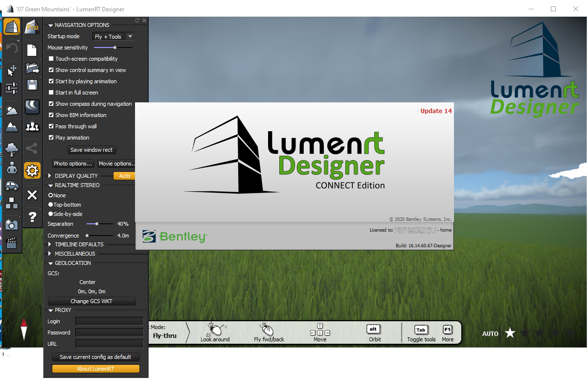
- Includes Bentley LumenRT Designer CONNECT Edition Update 14.
- Includes Bentley Descartes CONNECT Edition (V10.17.00.155).
- Update of gINT Civil Tools CONNECT Edition (V10.0.0.32).
- Support for following ProjectWise Connect Edition (V10.00.03.453).
- Includes Bentley Generative Components CONNECT Edition (V10.17.00.43).
- Updated Javarun-time engine to OpenJDK (18.0.1.1).
- Continued support for side-by-side installations of major versions. 2022 Release 1 can be installed side-by-side with earlier major versions. The second set of digits in the product version number shows the major version number. A 10.11 and 10.10 product can be installed side-by-side, but two 10.10 products cannot be installed side-by-side.
- Enhanced the Civil Feature Re-mapper tool to update terrain, geometry, corridors and template drops in a DGN file from one feature definition to another. Useful for situations such as upgrading project data from SS2/SS10 to OpenRoads Designer or moving files from one workspace to another.
- Added new Feature Definition Wizard.
- Added groups for Rail, Site, Analysis and D&U to better organize Feature Definitions in the Standards section of the Explorer.
- Enhanced the Details dialog to show categories in the header. This eliminates columns with duplicate names and makes it easier to use.
- Added documentation of Civil XML Schemas using Report Browser.
- Added support for ProjectWise Drive.
- For workspace changes please see \Configuration\Organization-Civil\Workspace Updates - 2022 Release 1.pdf included with the delivered workspace.
- New export formats are added to Export Geometry, WinALC (.geo) and SmartALC(.xgeo) formats for Plasser and Theurer tamping machines.
- New stationing formats were added to support 4 digits after + sign.
Survey Enhancements
- N/A
Geometry Enhancements
- Enhanced Station Offset and Station Base Reports to get elevations from Plain 3D elements and Survey chains.
- Enhanced Profile Intersection Point tool to allow the use of a selection set.
- Added support for exporting geometry to LandXML via key in/ script.
- Enhanced the Geometry Connector with way to set length of last and first element.
- Single Element Nudge tool now supports vertical geometry elements.
- Added Minimum Deviation Parameter to Create regression line tool.
Terrain Enhancements
- Added Gridded Elevation Difference tool between two terrains or terrain and plane.
- Added Compute Pond Volumes tool for incremental pond volumes with reporting.
- Added support for exporting terrains to LandXML via key in / script.
Modeling Enhancements
- Enhanced Cut/Fill tool with choice to delete existing meshes.
- Improved performance of Closed Mesh tool.
- Enhanced Closed Mesh tool to allow selecting closed shapes as boundaries in both 2D and 3D.
- Enhanced Closed Mesh tool to use selection sets.
- Add the ability to create, edit and manage Classification properties (formerly Semantics) from within the Create Template dialog.
- Create Coach Envelope tool now includes a choice to create Projected(2D) Swept Path envelope.
- Create Rail tool support for inclined rail profiles. 3D rail meshes are created with mirroring instead of copying the selected template.
- Added ability to use Cant Tables for cant calculations.
Drawing Production and Annotation Enhancements
- New Coordinate Grid tool for plan grid annotation.
- Added text field to include super elevation eMax in horizontal curve labels.
- Added text field to label active surface elevation at critical points (VPI, VPT) along a vertical geometry.
- Added text field to include Feature Definition Name in profile annotations.
- Added text field to label Horizontal (Projected) Length on cross section segments. This is in addition to the existing text field that labels Sloped (Actual) Length on cross section segments.
- Added ability to label the station ranges on sheets.
- Civil Labeler
. Moved label definitions into a DGNLib.
. Added ability to select multiple labels and drag to new folder.
. Added ability to import XML settings file from earlier versions into a DGNLib.
. Added ability to annotate between 2 points in a cross section.
. Added ability to override element template, dimension styles and text styles.
. Added ability to use the Active Attributes on label that does not have an Element Template defined.
. Added elongated hexagon as a frame.
. Added leader attachment points at corners (top left, bottom right, etc.) of the label.
. Added ability to lock label position to be perpendicular to a point or reference element.
Item Types Enhancements
- Added ability to calculate Station and Offset values with an expression. These expressions replace using the Asset Manager tool to compute stations and offsets.
- Added ability to calculate Latitude and Longitude with an expression.
- Enhanced Expression Builder to display civil schema and properties.
- Added ability to copy and paste the syntax for civil properties from the Properties dialog into the Expression Builder.
- Added support for hierarchical or conditional pick list.
- Added support for spaces, foreign characters and long strings in Excel column headers read by Lookup expressions.
- Added support for single source of truth to drainage nodes and conduits.
- Added configuration variable (CIVIL_QUICK_PROPERTIES_OMIT_ITEMTYPES) to control whether Item Types are displayed in the Quick Properties dialog.
- Added configuration variable (CIVIL_TOOL_SETTINGS_OMIT_ITEMTYPES) to control whether Item Types are displayed in the Tool Settings dialog.
- The product by default updates item type Last Valid Values when files are closed. This is the recommended workflow and should ONLY be overridden when a separate workflow is implemented to update Last Valid Values before taking files to other platforms such as MicroStation, iTwin, or IFC (Industry Foundation Classes). The configuration variable CIVIL_ITEMTYPE_UPDATE_LASTVALIDVALUE_ON_CLOSE can be used to override and not update Last Valid Values on close. This variable only needs to be defined to override the default behavior and stop the updates.
LVA/Signaling, Schematic and Topology Enhancements
- Topology Segments placed from end of an Edge.
- Topology model is enabled for a federated project setup.
- Added a Topology Routes property for Route Direction.
- Schematic model Edges are enabled for Drawing Production’s Named Boundary.
- Schematic model is enabled for a federated project setup.
- Point Object’s Feature Symbology is extended for Schematic model.
- New tools and features for Low Voltage Assets/Signaling:
. Added Feature Definitions: Low Voltage Assets -> Equipment, Trench and Cable .
. Tool for placing Equipment.
. Equipment extension feature for Equipment Assembly.
. Enabled Place Equipment tool for Schematic model.
. Tool for placing Trenches.
. Tool for creating a Trench from Geometry.
. Tool for placing Cable.
. Tool to update Schematic model.
. Tool for placing Clearance Point.
. User alert feature, which Equipment is updated due to geometry changes.
Drainage and Utilities Enhancements
- Implemented the Land Use Polygons available in OpenFlows 10.04.
- You can now connect a conduit to a connection point and it will trim to an intersected connection region or ring.
- You can now show the width of a conduit and the wall thickness in plan and profile.
- If a feature definition uses a prototype that is not in the DGN, it is copied from the DGNLib if it is available there.
- Added the ability to set the longitudinal slope for an inlet, instead of reading it from a terrain model or linear element.
- Added trench properties to the conduit feature definition.
- Added the ability to delete a utility project from a model in a DGN.
- You can now delineate the catchment for an existing inlet.
- You can now show multiple HGL's on a profile or profile run.
- Enhanced catchment shapes to support curves.
- Improved performance when computing a scenario.
- Added "Set Invert to Start/Stop" functionality for Utilities, to improve functionality and for consistency with Drainage.
- Connected pipes are now drawn on a projected profile.
- You can now use Element Templates to control the symbology of the HGL and EGL.
- The Insert Node tool now updates existing profile runs.
- A prompt now asks if you want to display the Model Integrity Check if the databases have elements that aren't in the DGN, when the DGN is opened.
- Added the ability to set the gap between multiple barrels on a conduit.
General Enhancements
- Update of Power Platform to Edition (V10.17.00.990).
- Subscription Entitlement Service (formerly CONNECT Licensing) is utilized. For more information: Subscription Entitlement Service .
- This version uses OpenFlows SewerGEMS version 10.04.00.123. More information here: What's New in SewerGEMS, CivilStorm, StormCAD, SewerCAD, and SewerOPS CONNECT Edition Update 3 (version 10.03.04.53) - OpenFlows | Hydraulics and Hydrology Wiki - OpenFlows | Hydraulics and Hydrology - Bentley Communities
- Includes Bentley LumenRT Designer CONNECT Edition Update 14.
- Includes Bentley Descartes CONNECT Edition (V10.17.00.155).
- Update of gINT Civil Tools CONNECT Edition (V10.0.0.32).
- Support for following ProjectWise Connect Edition (V10.00.03.453).
- Includes Bentley Generative Components CONNECT Edition (V10.17.00.43).
- Updated Javarun-time engine to OpenJDK (18.0.1.1).
- Continued support for side-by-side installations of major versions. 2022 Release 1 can be installed side-by-side with earlier major versions. The second set of digits in the product version number shows the major version number. A 10.11 and 10.10 product can be installed side-by-side, but two 10.10 products cannot be installed side-by-side.
- Enhanced the Civil Feature Re-mapper tool to update terrain, geometry, corridors and template drops in a DGN file from one feature definition to another. Useful for situations such as upgrading project data from SS2/SS10 to OpenRoads Designer or moving files from one workspace to another.
- Added new Feature Definition Wizard.
- Added groups for Rail, Site, Analysis and D&U to better organize Feature Definitions in the Standards section of the Explorer.
- Enhanced the Details dialog to show categories in the header. This eliminates columns with duplicate names and makes it easier to use.
- Added documentation of Civil XML Schemas using Report Browser.
- Added support for ProjectWise Drive.
- For workspace changes please see \Configuration\Organization-Civil\Workspace Updates - 2022 Release 1.pdf included with the delivered workspace.
- New export formats are added to Export Geometry, WinALC (.geo) and SmartALC(.xgeo) formats for Plasser and Theurer tamping machines.
- New stationing formats were added to support 4 digits after + sign.
Survey Enhancements
- N/A
Geometry Enhancements
- Enhanced Station Offset and Station Base Reports to get elevations from Plain 3D elements and Survey chains.
- Enhanced Profile Intersection Point tool to allow the use of a selection set.
- Added support for exporting geometry to LandXML via key in/ script.
- Enhanced the Geometry Connector with way to set length of last and first element.
- Single Element Nudge tool now supports vertical geometry elements.
- Added Minimum Deviation Parameter to Create regression line tool.
Terrain Enhancements
- Added Gridded Elevation Difference tool between two terrains or terrain and plane.
- Added Compute Pond Volumes tool for incremental pond volumes with reporting.
- Added support for exporting terrains to LandXML via key in / script.
Modeling Enhancements
- Enhanced Cut/Fill tool with choice to delete existing meshes.
- Improved performance of Closed Mesh tool.
- Enhanced Closed Mesh tool to allow selecting closed shapes as boundaries in both 2D and 3D.
- Enhanced Closed Mesh tool to use selection sets.
- Add the ability to create, edit and manage Classification properties (formerly Semantics) from within the Create Template dialog.
- Create Coach Envelope tool now includes a choice to create Projected(2D) Swept Path envelope.
- Create Rail tool support for inclined rail profiles. 3D rail meshes are created with mirroring instead of copying the selected template.
- Added ability to use Cant Tables for cant calculations.
Drawing Production and Annotation Enhancements
- New Coordinate Grid tool for plan grid annotation.
- Added text field to include super elevation eMax in horizontal curve labels.
- Added text field to label active surface elevation at critical points (VPI, VPT) along a vertical geometry.
- Added text field to include Feature Definition Name in profile annotations.
- Added text field to label Horizontal (Projected) Length on cross section segments. This is in addition to the existing text field that labels Sloped (Actual) Length on cross section segments.
- Added ability to label the station ranges on sheets.
- Civil Labeler
. Moved label definitions into a DGNLib.
. Added ability to select multiple labels and drag to new folder.
. Added ability to import XML settings file from earlier versions into a DGNLib.
. Added ability to annotate between 2 points in a cross section.
. Added ability to override element template, dimension styles and text styles.
. Added ability to use the Active Attributes on label that does not have an Element Template defined.
. Added elongated hexagon as a frame.
. Added leader attachment points at corners (top left, bottom right, etc.) of the label.
. Added ability to lock label position to be perpendicular to a point or reference element.
Item Types Enhancements
- Added ability to calculate Station and Offset values with an expression. These expressions replace using the Asset Manager tool to compute stations and offsets.
- Added ability to calculate Latitude and Longitude with an expression.
- Enhanced Expression Builder to display civil schema and properties.
- Added ability to copy and paste the syntax for civil properties from the Properties dialog into the Expression Builder.
- Added support for hierarchical or conditional pick list.
- Added support for spaces, foreign characters and long strings in Excel column headers read by Lookup expressions.
- Added support for single source of truth to drainage nodes and conduits.
- Added configuration variable (CIVIL_QUICK_PROPERTIES_OMIT_ITEMTYPES) to control whether Item Types are displayed in the Quick Properties dialog.
- Added configuration variable (CIVIL_TOOL_SETTINGS_OMIT_ITEMTYPES) to control whether Item Types are displayed in the Tool Settings dialog.
- The product by default updates item type Last Valid Values when files are closed. This is the recommended workflow and should ONLY be overridden when a separate workflow is implemented to update Last Valid Values before taking files to other platforms such as MicroStation, iTwin, or IFC (Industry Foundation Classes). The configuration variable CIVIL_ITEMTYPE_UPDATE_LASTVALIDVALUE_ON_CLOSE can be used to override and not update Last Valid Values on close. This variable only needs to be defined to override the default behavior and stop the updates.
LVA/Signaling, Schematic and Topology Enhancements
- Topology Segments placed from end of an Edge.
- Topology model is enabled for a federated project setup.
- Added a Topology Routes property for Route Direction.
- Schematic model Edges are enabled for Drawing Production’s Named Boundary.
- Schematic model is enabled for a federated project setup.
- Point Object’s Feature Symbology is extended for Schematic model.
- New tools and features for Low Voltage Assets/Signaling:
. Added Feature Definitions: Low Voltage Assets -> Equipment, Trench and Cable .
. Tool for placing Equipment.
. Equipment extension feature for Equipment Assembly.
. Enabled Place Equipment tool for Schematic model.
. Tool for placing Trenches.
. Tool for creating a Trench from Geometry.
. Tool for placing Cable.
. Tool to update Schematic model.
. Tool for placing Clearance Point.
. User alert feature, which Equipment is updated due to geometry changes.
Drainage and Utilities Enhancements
- Implemented the Land Use Polygons available in OpenFlows 10.04.
- You can now connect a conduit to a connection point and it will trim to an intersected connection region or ring.
- You can now show the width of a conduit and the wall thickness in plan and profile.
- If a feature definition uses a prototype that is not in the DGN, it is copied from the DGNLib if it is available there.
- Added the ability to set the longitudinal slope for an inlet, instead of reading it from a terrain model or linear element.
- Added trench properties to the conduit feature definition.
- Added the ability to delete a utility project from a model in a DGN.
- You can now delineate the catchment for an existing inlet.
- You can now show multiple HGL's on a profile or profile run.
- Enhanced catchment shapes to support curves.
- Improved performance when computing a scenario.
- Added "Set Invert to Start/Stop" functionality for Utilities, to improve functionality and for consistency with Drainage.
- Connected pipes are now drawn on a projected profile.
- You can now use Element Templates to control the symbology of the HGL and EGL.
- The Insert Node tool now updates existing profile runs.
- A prompt now asks if you want to display the Model Integrity Check if the databases have elements that aren't in the DGN, when the DGN is opened.
- Added the ability to set the gap between multiple barrels on a conduit.
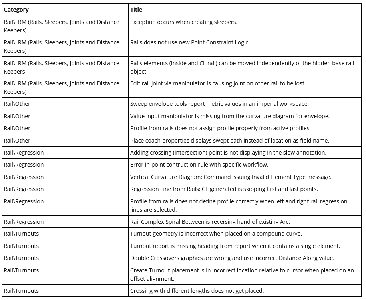
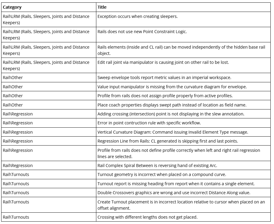
This section provides a list of defects that have been resolved in this release of OpenSite Designer.
![OpenSite Designer CONNECT Edition 2022 Release 1]()
![OpenSite Designer CONNECT Edition 2022 Release 1]()
OpenSite Designer CONNECT Edition 2022 Release 1
OpenSite Designer CONNECT Edition 2022 Release 1
OpenSite Designer CONNECT Edition 2022 Release 1
OpenSite Designer CONNECT Edition 2022 Release 1
OpenSite Designer CONNECT Edition 2022 Release 1
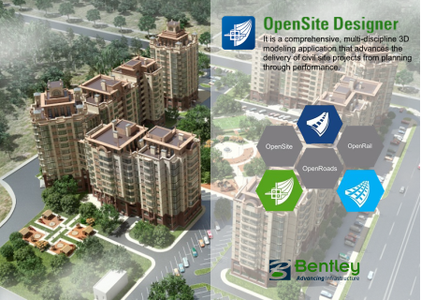
OpenSite Designer CONNECT Edition is the successor to Bentley’s design brands GEOPAK Site, GEOPAK Survey, InRoads Site, InRoads Site Suite, InRoads Storm and Sanitary, InRoads Survey, PowerSurvey, MXGRONDWERK, MXGRONDWERK Addin, MXSITE, MXSUBDIV, Bentley topoGRAPH, Bentley topoGRAPH Projects, Bentley Subsurface Utility Engineering. It is a comprehensive, multi-discipline 3D modeling application that advances the delivery of civil site projects from planning through performance.
OpenSite Designer blends traditional engineering workflows for plan, profile, and earthworks with 3D parametric modeling and earthwork optimization to enable the model-centric creation of all design deliverables.
OpenSite Designer handles a wide variety of complex tasks such as parking configurations, analysis earthwork financial risk, residential layout, handicap parking and accessibility, site development, sanitary and stormwater network design, and producing construction staking reports.
OpenSite Designer enables users to create intelligent geometrics and 3D models containing site information, terrain data, parking lots, building pads, driveways, sidewalk, parcel layout and related site features. OpenSite Designer provides a comprehensive modeling environment and addresses all phases of project delivery. It provides a breadth of applications to meet the demands of each phase of the project lifecycle, including:
- Contextual Design. All detailed design in OpenSite Designer is driven by functional components, which inherently respond contextually to express appropriate design, annotation, and plan set display behaviors. Design models are expressed in multiple live views including plan, profile, and 3D. Changes in one view are live and dynamically update all views
- Multi-discipline Support. OpenSite Designer integrates support for each discipline with specific user profiles dedicated to each discipline. Users can switch discipline perspectives, for instance from grading design to subsurface utility design.
- Reality Modeling Tools. OpenSite Designer includes a fully functional toolset to incorporate and edit reality modeling data types, including the capability to extract ground-level features from reality meshes and LiDAR, as well as to reference point clouds and imagery.
- Geotechnical Tools. Users can connect directly to gINT geotechnical databases to incorporate subsurface terrain details into
- their models for improving grading and piling. Subsurface terrains can be generated or modeled based on the bore hole materials and projected in road and drainage profiles, sections, and plans.
- Subsurface Utilities. Users can select from a large catalog of functional components for utility and drainage to model underground drainage and utility networks. Drainage models can be optimized for water flow using integrated water analysis capabilities, with results available in data tables or visually in a profile view.
- Rich Deliverables. An expanded set of deliverables range from traditional plan sets and animations to digital construction models—for automated machine control and field positioning systems for excavation, grading, and piling.
- Live Plan Generation. Plan generation no longer needs to be a separate process limited to a point in time, as settings and annotations are dynamically updated and live in the model. Views are saved with specific display rules and sheet index embedded, making it easy to navigate between the model and drawings. Up-to-date drawings can be generated automatically at any time, creating a natural and fluid design environment for both modeling and detailing.
- Enlivened Visualization. OpenSite Designer provides direct integration to LumenRT to produce cinematic visualization, adding vegetation, reflecting nature, and climate.
Designs created in OpenSite Designer benefit from BIM Review through Navigator, in the office, field, and at the site. Navigator enables not only visualization and review of 3D designs, but also status visibility—allowing dispersed teams to progress approvals and the resolution of issues
This video demonstrates where the predefined design parameters and layout properties are configured inside of OpenSite Designer.
Bentley Systems is a software development company that supports the professional needs of those responsible for creating and managing the world’s infrastructure.
Product: OpenSite Designer
Version: CONNECT Edition 2022 R1 (10.11.00.115)
Supported Architectures: x64
Website Home Page : www.bentley.com
Languages Supported: english
System Requirements: Windows *
Size: 7.7 Gb
OpenSite Designer CONNECT Edition 2022 Release 1
Please visit my blog
Added by 3% of the overall size of the archive of information for the restoration
No mirrors please

![OpenSite Designer CONNECT Edition 2022 Release 1]()
Added by 3% of the overall size of the archive of information for the restoration
No mirrors please
OpenSite Designer CONNECT Edition 2022 Release 1
