Tags
Language
Tags
April 2024
Su Mo Tu We Th Fr Sa
31 1 2 3 4 5 6
7 8 9 10 11 12 13
14 15 16 17 18 19 20
21 22 23 24 25 26 27
28 29 30 1 2 3 4
https://canv.ai/
The picture is generated by canv.ai

We are excited to announce that Canv.ai now features a built-in translator, allowing you to communicate in your native language. You can write prompts in your language, and they will be automatically translated into English, facilitating communication and the exchange of ideas!

We value freedom of speech and guarantee the absence of censorship on Canv.ai. At the same time, we hope and believe in the high moral standards of our users, which will help maintain a respectful and constructive atmosphere.


👉 Check for yourself!

CreativeMarket - U.S. Letter Trifold Brochure Mock-Up 2929498

Posted By: LENYAA
CreativeMarket - U.S. Letter Trifold Brochure Mock-Up 2929498

CreativeMarket - U.S. Letter Trifold Brochure Mock-Up 2929498
PSD | 86.97 MB

CreativeMarket - Beer Bottle Mockup 3605950

Posted By: LENYAA
CreativeMarket - Beer Bottle Mockup 3605950

CreativeMarket - Beer Bottle Mockup 3605950
PSD, PDF | 69 mb

Minimalist CV Resume Vol. 20

Posted By: LENYAA
Minimalist CV Resume Vol. 20

Minimalist CV Resume Vol. 20
PSD,AI,EPS | 15.1 MB

Detailed World Maps Collection

Posted By: maxlights58
Detailed World Maps Collection

Detailed World Maps Collection
format JPEG | up to 6000x4699 | 70 Mb

This collection include many detailed maps of the world and various continents: America, Europe, Antarctica. Some maps are also provided with detailed interesting descriptions and additional clarifying materials. The maps are very detailed and can easily be used for printing.

CreativeMarket - Barber Shop - Mockup Generator 2430479

Posted By: Sigha
CreativeMarket - Barber Shop - Mockup Generator 2430479

CreativeMarket Barber Shop - Mockup Generator 2430479
PSD | 2.36 GB

Sea Charts - Medieval Maps & Atlases

Posted By: maxlights58
Sea Charts - Medieval Maps & Atlases

Sea Charts - Old Medieval Maps and Atlases
format JPEG | 67 high quality maps | ~4500x2400 | 232 Mb

This is big collection of old medieval maps and atlases which can be printed on a sheet of large format. Maps scanned very accurately with the preservation of all small elements and maps presented from 13th to the 18th century. Additional images show different episodes from the Middle Ages associated with travel and new cartographic discoveries.

World Atlas - Ortelius Theatrum Orbis Terrarum

Posted By: maxlights58
World Atlas - Ortelius Theatrum Orbis Terrarum

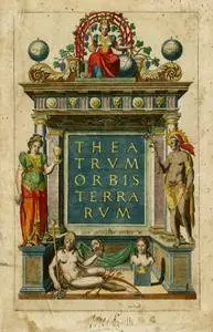
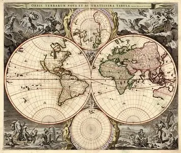
World Atlas Ortelius Theatrum Orbis Terrarum
format TIF | 7000x5000 | 54 high-res scans | 5.23 Gb

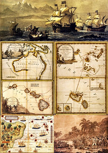
Ortelius compiled the world's first geographic atlas, consisting of 53 large-format maps with detailed explanatory geographical texts, which was published in the city of Atveres on May 20, 1570. The Atlas was named Theatrum Orbis Terrarum and reflected the state of geographical knowledge on that time. This atlas was repeatedly supplemented and republished and was very popular among navigators of the late 16th - early 17th centuries. Along with the Mercator Atlas, he also played an important role in the development of cartography.

Vintage Old Maps Gold Collection

Posted By: maxlights58
Vintage Old Maps Gold Collection

Vintage Old Maps Gold Collection
19 JPEG | max.4990x4250 | 345 Mb

This is new collection of old maps and atlases which can be printed on a sheet of large format. Maps scanned very accurately with the preservation of all small elements and maps presented from ancient times to the 18th century.

Cartographic Old World Atlases Collection

Posted By: maxlights58
Cartographic Old World Atlases Collection

Cartographic Old World Atlases Collection
17 JPEG | up to 15472х12638 | 360 Mb

This is a collection of old maps and atlases of increased detail, which can be printed on a sheet of very large format. The Atlas were created by famous world cartographers (Carington Voyvs, Thomas Kitchen, William Faden, George Villiday and others) in the 18th century.

World Atlas - Civitates Orbis Terrarum

Posted By: maxlights58
World Atlas - Civitates Orbis Terrarum

World Atlas Civitates Orbis Terrarum
format JPEG | up to 4100x1450 | 336 Mb

The Atlas of the cities of the terrestrial world (Civitates Orbis Terrarum) was released in the 16th century (it was published for 46 years - from 1572 to 1618). A total of six volumes were published. Authors of the atlas - engraver and publisher Frans Hogenberg and theologian George Brown. The Atlas was published in Cologne, but nevertheless belongs to the Antwerp cartographic school. In addition, it is known from the personal correspondence of the authors of the atlas that the idea of creating an atlas was born exactly in Antwerp. Atlas is the second time printed atlas in world.

Antique Atlas & Maps Collection

Posted By: maxlights58
Antique Atlas & Maps Collection

Antique Atlas and Maps Collection
80 JPEG & TIF | up to 7790x6260 | 434 Mb

Heavily decorated 18th Century maps of the world

Posted By: nrg
Heavily decorated 18th Century maps of the world

Heavily decorated 18th Century maps of the world
6 jpg | up to 15472*12638 | SUHQ | 201.4 Mb

CreativeMarket - 3 Topographic Elevation Maps

Posted By: AlenMiler
CreativeMarket - 3 Topographic Elevation Maps

CreativeMarket - 3 Topographic Elevation Maps
EPS + PNG | 8000x6100 | 8.5x11 vector | 22.05 Mb

Ukraine map - Stock Vectors

Posted By: DesLord
Ukraine map - Stock Vectors

Ukraine map - Stock Vectors
5 EPS | + JPG Preview | 16 Mb rar

Old Medieval Maps & Manuscripts

Posted By: maxlights58
Old Medieval Maps & Manuscripts

Old Medieval Maps, Pictures, Illustrations & Manuscripts
174 JPEG | max.5345x3580 | 459 Mb