

OCAD 12.1.8.1187 Multilingual
OCAD 12.1.8.1187 Multilingual | 160.2 MB
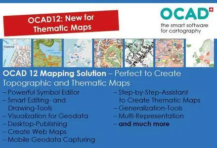
OCAD is more than just a map drawing software. OCAD provides you with a powerful software package for producing and editing any kind of maps (e.g. topographic maps, city maps, hiking and biking maps, Internet maps). It provides interfaces within the following fields: Geodata Capture (mobile application), Import and Export of Geodata, Desktop Publishing (DTP) and creating Web Maps. Moreover, with the latest add-on – the ThematicMapper – it enables you to create even thematic maps with OCAD.
Geodata Capture.
Our Software can be installed very quicky and runs easily on Windows tablet PC's due to its streamlined software and efficiently used hardware resources. Moreover, OCAD has an interface to receive GPS and laser range finder (TruPuls) signals. Therefore, OCAD is very much suitable for geodata capturing. With the same software package you can capture data, and finally edit and publish it. In addition, the import and export tools for GPS data (GPX, NMEA files etc.) widen the range of possible GPS applications.
Import and Export of Geodata.
Vectorization of digital background maps is one of the most powerful and efficient applications of OCAD. However, nowadays a lot of (vectorized) geodata are provided at an affordable price (e.g. SHP or DXF file format) by national topographic or geodetic institutes, or even free of charge by OpenStreetMap. Therefore, OCAD has developed an import and export function for geodata (SHP, DXF, OSM files etc.), which helps you to assign geodata to your predefined map symbols automatically and maintain the provided original geodata base as well (ODBC Connection).
Desktop Publishing.
Printed maps are still very popular because of their multifunctional and simple application. For that reason, OCAD provides several export formats (Adobe Illustrator, PDF, SVG, EPS etc.) so that maps can be printed in a DTP environment. Furthermore, DTP files (Adobe Illustrator, PDF, SVG etc.) can also be imported into OCAD in order to benefit from its specific cartographic drawing and editing tools or to transfer them into a GIS environment.
Internet Maps.
The OCAD Internet Map (OIM) Wizard helps you to create an interactive Web version of your maps. Step by step, you can decide how many zoom levels your map should have or which hotspots, links or search functions should be added. However, if you prefer a static version of your map, you can export it in raster format or wrap it over one of the Planet Browsers (KML/KMZ).
Worldwide Use of OCAD.
OCAD is available in 16 languages (English, Catalan, Czech, Finnish, French, German, Hungarian, Italian, Japanese, Norwegian, Polish, Portuguese, Russian, Swedish, Spanish and Turkish) and is being used successfully in more than 77 countries in a great variety of sectors: map publishers, national institutes of cartography and topography, land surveying offices, town-, district- and municipality planning, fire brigades, graphics firms, planning and engineering offices, schools, universities, army headquarters, sport and recreation clubs etc.
OS : Windows 10/8/7/Vista/XP
Language : Multilingual
Home Page - http://www.ocad.com/