

Lucys Globe 1.01 Multilanguage

Lucys Globe 1.01 Multilanguage | 1.32 MB
The main aim of this program is to improve you geographical knowledge - especially about states and their capitals.
Lucy's Globe trains at the same time geographical and foreign language knowledge. The shareware program shows a colorful globe on the screen and in a puzzle like mode puts learners on the task to select the name and capital for the right state. The globe can be comfortably turned in any direction with clicking and pulling with the mouse. Addingly, there is a magnification glass which allows to find states as little as Andorra or the Vatican.
A multilingual globe and geography puzzle
The language of the user interface of Lucy's Globe and the language of the data (language which is used for the labels on the globe and in the different tables) can be chosen independently of each other. At this time the following languages are at your disposition:- User interface language: English, German, Spanish - Data language: English, German, Spanish, French Nevertheless the administrative parts – the parts used for changing the data – only
exist in English.
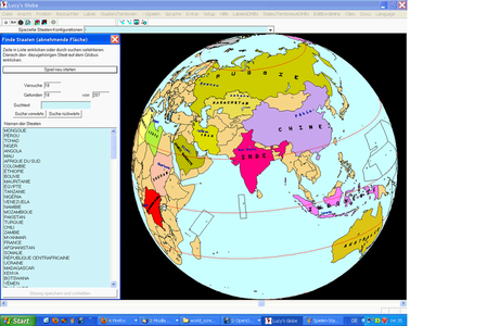
Globe Puzzle – Earth Puzzle – States Puzzle
With Lucy's Globe you can improve your geographical knowledge and at the same
time not only learn the corresponding vocabulary in English but also in Spanish,
German and French. An this, you do it while playing because the globe transforms
into a geographical puzzle as soon as you choose the corresponding puzzle globe
mode: All countries get the same color and all labels disappear. At the same time a
list opens which contains the states or their capitals which are sorted according to
the criteria you have chosen: surface, population, population density, alphabetical
or random.
Now the task consists in choosing a state or capital in the list and to click the
corresponding state on the globe. If a state has been selected which is composed of
several parts, you can click each part – in the case of France for example you can
click French Guyana or French Polynesia… Each time when a state has been found,
it will be repainted in its specific color and its name and the name of its capital
appear. At the same time, the state or capital disappears from the list.
Some states are so tiny that they appear only as point or as several points. This
cannot easily be clicked. For this reason a magnification glass is available, which
can for example be selected after having clicked the right mouse button. But the
real problem are not the tiny states of which you know the position but the tiny
states for which you do not yet know the position. In this case the magnification
glass is of no use. Clicking randomly also will not be of much help. If you don't
know where is Singapore for example, then there is no other choice than to choose
the menu item “States/Territories” and then the subitem “States/territories table…”.
In the dialog which opens, you have just to search for “sing”. Then the globe turns
so that Singapore comes in the middle, which is also shown by blinking circles.
Now you can use the magnification glass to make Singapore visible in order to
click on it.
Base data about a state
If you just want to recall the base data for some state (or island), you only need to
click the state with the right mouse button and then to select “State/Territory
infobox…”. A box will be opened indicating surface, population, population density.
Possibly you will also see a comment which is necessary in the case of puzzle
countries like Greenland which is still partly dependent on Denmark but not part of
the EU. Greenland and some other countries are really puzzle states or puzzle
countries which caused me real headaches.
Compare base data between states
You can use the infobox to compare the data between two different states but also
the States/Territory table. In this table you can sort the countries according to their
name, the name of the capitals, the continent, the surface, the population, the
population density and the existence or not of a comment.
Groups of states
Lucy's Globe gives you an overview on different states groups like the European
Union, the League Arab, the countries with circulation on the left side…
Find a sea or an island
If you click on the menu item “Labels“ and then on “List of labels…”, you will get
all the labels on the globe in a list. Do you want to know where is the Banda Sea?
Then just search for “Banda Sea” in this list and the globe will turn so that the label
“Banda Sea” comes in the middle (the middle of the label is shown with blinking
circles). You can of course also search for the label of a state or a capital or even for
a label you have entered yourself.
An extensible and customizable globe
Maybe you are interested in adding labels or even label categories. You can even
add you own groups of states, a tiny island which is of special for you, or some
cities. And if for example New Caledonia should become independent, then this is
not a problem of Lucy's Globe but merely a data problem and these data can be
adapted by Lucy's Globe.
Globe pictures for your documents
You need a globe picture or globe pictures or pictures of parts of the globe ? Lucy's
Globe gives you the possibility to export the picture you need and to use it freely.
As author of this globe software I grant you all rights to do it.