

World atlas & map MxGeo Pro3.1

World.atlas.map.MxGeo.Pro.3.1 | 7.95 MB
World atlas, world map and educational application for geography. Contains 239 countries and territories of the world with economic and geopolitical data. Detailed maps with regional division (provinces), capitals and major cities included.
Designed for smartphones and tablets. Optimized for HD displays. Available Languages: English, German, French, Arabic and Spanish.
- Maps, flags and basic data for 239 countries and territories of the world
- Zoomable world, continent and country maps
- Geography quiz challenge for playful learning
- Country comparison and favorites
- Configurable world clock with time zone display
- World-explorer: the smallest, largest, wealthiest, and most populated countries of the world
- Choosable color themes for map display
- Fast search with auto-complete suggestions
- All data and maps included - NO online connection required
- No advertising or In App Purchases
- No permissions required
Explore the world through detailed continent and country maps. Whether Europe, Africa, Asia, South and North America: maps of all continents and countries are included. See the position of each country highlighted on a digital globe (world map). Choose your favorite theme from 5 color schemes for map display.
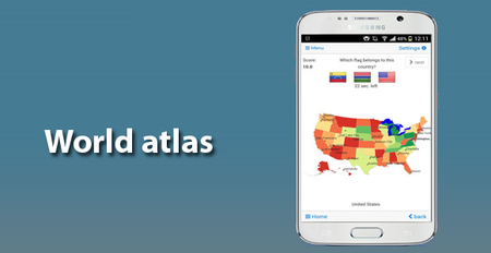
Quiz challenge for acquiring geographic literacy in a playful manner.
Choose from 5 guessing games:
- Test your knowledge about the capitals in the world
- Recognize the right country flag based on the outline map
- Do you know the top-level domains of the world's countries
- Guess the highlighted country on the virtual globe
- Do you know the ISO countries codes of the world
Geo learning app and educational game which is fun for everyone whether children, adults, seniors or teachers. Get ready for your next stay abroad while enjoying this great world almanac including time zones and statistical data, such as population growth, unemployment rate, average age, gross domestic product (GDP) by sector and other key figures. Or prepare for your next geography lesson with this genius digital world map. If not traveling our world atlas lets you explore the world just only virtually.
Have fun with our detailed political maps of the World, Europe, Asia, North America, Africa, Oceania and South America with all countries including regional units (provinces) and capitals and major cities.
What's new:
- Full screen bug fixed
- UI and performance optimization
- Optional high quality mode for virtual globe
- Close app option added
- Alternative geo projections for world map
- World clock: time zones map optimized
- Corrections and updates of country data and maps