

HoudahGeo 5.0.8 Multilangual Mac OS X
HoudahGeo 5.0.8 Multilangual | MacOSX | 27.7 MB
HoudahGeo: Know where you took that photo! HoudahGeo is a photo geocoding & geotagging solution made for Mac OS X. It "pins" photos to locations where they were taken. Just like a GPS-enabled camera, HoudahGeo can store latitude, longitude and altitude information right within the image file. HoudahGeo writes industry standard EXIF, XMP and IPTC tags to JPEG and RAW images without recompression or loss of quality.
Know Where You Took That Photo!
Use HoudahGeo to geocode and geotag your photos. “Pin” photos to the exact locations where they were taken.
HoudahGeo stores latitude, longitude and altitude as geotags right within the image file. Just like a GPS-enabled camera.
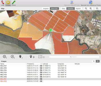
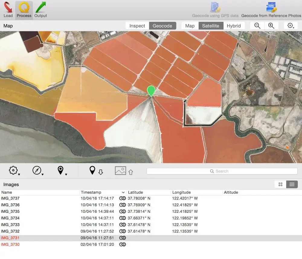
HoudahGeo supports many methods of geocoding, ranging from automatic to manual. Use a GPS track log, reference photos taken with iPhone or pick locations on the built-in map.
HoudahGeo integrates with Apple Photos, iPhoto, Aperture, and Adobe Lightroom. It can notify iPhoto or Aperture when places information has been updated.
View. Organize. Find!
Geotags tie your photos to geographical locations. View your photos on a map. Use your favorite photo cataloging tools to organize and find photos by places.
Future-proof your photos with geotags. HoudahGeo writes EXIF, XMP, and IPTC metadata tags to JPEG and RAW image files. Industry standards ensure that the information can be used by a wide variety of software and services.
Geotagging is essential for professionals who need to know and show where photos were taken. E.g. to document wildlife migration, locate structure damage, enhance real estate listings, etc.
Automatic Geocoding
Use a GPS device, a track logger, or your phone to record a GPS track log. HoudahGeo matches your photos to data points in the track log.
HoudahGeo reads many common track log file formats: GPX, NMEA, Garmin FIT, Wintec TES, etc.
HoudahGeo can also connect to a wide variety of GPS devices. Download the trial version to check if your device is supported.
Geocoding Without a GPS
Use the built-in map to double-check, adjust, or assign locations to your photos. Drag images to map locations for quick geocoding.
HoudahGeo also connects to Google Earth where you can pick locations from the globe.
Use your iPhone or GPS-enabled camera to take geotagged reference photos. HoudahGeo uses these to geocode photos taken during the same timeframe.
Use HoudahGeo Places to quickly assign coordinates and location names to photos taken at your favorite spots.
View and Update Metadata
HoudahGeo saves metadata to industry standard EXIF, XMP, and IPTC metadata tags without recompression or loss of quality.
HoudahGeo works with JPEG as well as a large number of RAW file formats. It also supports XMP sidecar files.
Use HoudahGeo to add location names, titles, descriptions and keywords to your photos.
Reverse geocoding fills in city, province and country names.
Browse Apple Photos, iPhoto, Aperture, and Adobe Lightroom libraries. Access both edited versions and original image files.
Notify iPhoto or Aperture of updated places information.
Show Photos in Context
See your photos set along the path you travelled.
Create KMZ or KML files from GPS tracks and photos. View these using Google Earth or Google Maps.
Imagine going on a safari. Return home and see a bird's-eye view of your journey. Locate the exact tree that leopard was perched in.
Publish photos and KML files to Dropbox for your friends to view in Google My Maps.
New in HoudahGeo 5.0.8
- Improved performance of EXIF / XMP export
- Compatibility fix for GPS devices based on SkyTraq chipsets
System requirements: Mac OS X 10.10 or later.
Home Page - http://www.houdah.com/houdahGeo/
No mirrors please