


AlpineQuest GPS Hiking v1.3.1

AlpineQuest GPS Hiking v1.3.1
Android | .apk | 2.2mb
Turn your Android device into a real off-road GPS using off-line topo maps! AlpineQuest GPS Hiking is the complete solution for all outdoor activities and sports, including hiking, running, trailing, hunting, sailing, geocaching and much more.
AlpineQuest GPS Hiking v1.3.1

AlpineQuest GPS Hiking v1.3.1

AlpineQuest GPS Hiking v1.3.1
AlpineQuest GPS Hiking v1.3.1
Turn your Android device into a real off-road GPS using off-line topo maps!
AlpineQuest GPS Hiking is the complete solution for all outdoor activities and sports, including hiking, running, trailing, hunting, sailing, geocaching and much more.
You can access and store locally a large range of on-line topographic maps, which will remain available even while being out of cell coverage. AlpineQuest also supports on-board file based maps, like MemoryMap© maps.
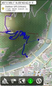
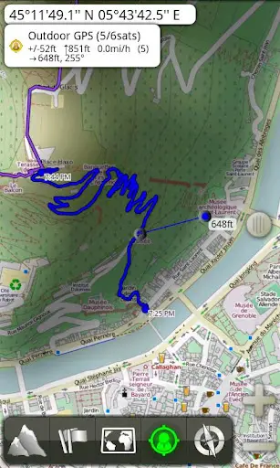
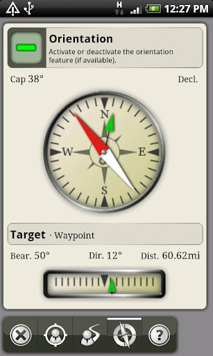
By using the GPS and the magnetic sensor of your device (with compass display), getting lost is part of the past: you are localized in real-time on the map, which can also be oriented to match where you are looking at.
Save and retrieve landmarks, share them with your friends. Track your path, get advanced statistics and interactive graphics. You won't have anymore question about what you can accomplish.
By staying fully operational out of cell coverage (as often in mountain or abroad), AlpineQuest assists you in all your desires of deep wilderness exploring…
Don't hesitate, try the free Lite version right now!
Note: IGN Top25© and OSGB Explorer© maps are available in MemoryMap© format, but NOT included with the application.
PLEASE report suggestions and issues on our dedicated forum: http://forum.psyberia.net (no registration needed, all questions answered).
Do not use comments for that: we cannot answer!
Key features are:
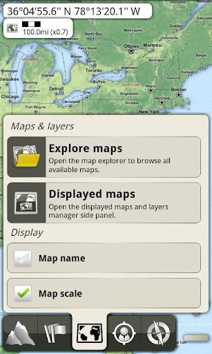
*** Maps ***
• Built-in online maps (with automatic local storage; road, topo and satellite maps included);
• Built-in online layers (road names and hills shading);
• Get more online maps and layers in one click from the included community map list (Nokia maps, USGS Topo, …);
• On-board offline maps support (visit our website to get the free map creator MOBAC);
• Memory-Map support (QuickChart .qct maps only, test your maps using the free version first);
• Multiple maps in layers display, with per-map opacity control;
• Advanced SD memory card Map Explorer and Scanner.
*** Landmarks ***
• Full GPX support (display/browse/create/edit of waypoints, routes and tracks);
• KML and LOC files support;
• Save and share online locations with other users using Community Landmarks;
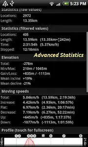
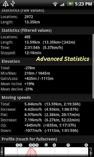
• Details, advanced statistics and interactive graphics on various items;
• Time Controller to replay time-tagged tracks;
• GPX Routes and KML Rings creators;
• Advanced SD memory card Landmarks Explorer.
*** Geolocation / Orientation ***
• On-map geolocation using GPS or Network;
• Map orientation, compass and target finder;
• Built-in GPS Tracker (long tracking capable, running in a separate and light process);
• Barometer support (for compatible devices).
And more:
• Full screen map view;
• Multi-touch zoom;
• Longitude/Latitude and grid coordinates (UTM, USNG, MGRS, OSGB, Irish, CH1903);
• Metric and imperial distance units;
• …
About the "Phone state and identity" Android permission: due to the backward compatibility of AlpineQuest with Android 1.5, this permission is automatically added by Google Play (see http://stackoverflow.com/a/1750875).
Requirements: Android 1.5+
More Info:
https://play.google.com/store/apps/details?id=psyberia.alpinequest.full