


Coursera - Geospatial Intelligence & the Geospatial Revolution (2016)

Coursera - Geospatial Intelligence & the Geospatial Revolution (2016)
Pennsylvania State University with Todd Bacastow
WEBRip | English | MP4 | 960 x 540 | AVC ~282 kbps | 29.970 fps
AAC | 128 Kbps | 44.1 KHz | 2 channels | Subs: English (.srt) | 01:22:22 | 219 MB
Genre: eLearning Video / Civil & Environmental Engineering
Pennsylvania State University with Todd Bacastow
WEBRip | English | MP4 | 960 x 540 | AVC ~282 kbps | 29.970 fps
AAC | 128 Kbps | 44.1 KHz | 2 channels | Subs: English (.srt) | 01:22:22 | 219 MB
Genre: eLearning Video / Civil & Environmental Engineering
Join us for the exciting journey to learn about GEOINT’s application in business, law enforcement, and defense. Advances in satellites, GPS, unmanned aerial systems, wireless communications, handheld computing, and the ability to automate laborious map analysis processes has transformed what used to be called geographic intelligence, or GEOINT, and the nature of the insights provided to managers and leaders. GEOINT is more than just analysts working with GIS in a secure intelligence facility.We have gone from mountains of hardcopy maps to amazing automated systems that provide previously unavailable understanding. GEOINT helps us daily with real-time apps to guide decision making. GEOINT combines geographic information science and technologies with an analytic tradecraft. In this course you will experience the value of GEOINT. You will learn how to design and execute a geospatial analysis project using GEOINT tools and tradecraft. The course is designed for the individual who wants to learn the basics of GEOINT and it is not designed for the geospatial intelligence professional. We're eager to welcome you to the Revolution.
Syllabus
Week One: What is GEOINT?
Learn what GEOINT is and how it provides a powerful way of thinking about and finding solutions to complex humanitarian, military, economic, and cultural problems. We'll discuss the role of secrecy and its challenges.
Week Two: GEOINT Data.
Examine the types and nature of data used to create GEOINT, including textual information, imagery, and geospatial data. Discuss how location-based data is changing conceptions of privacy.
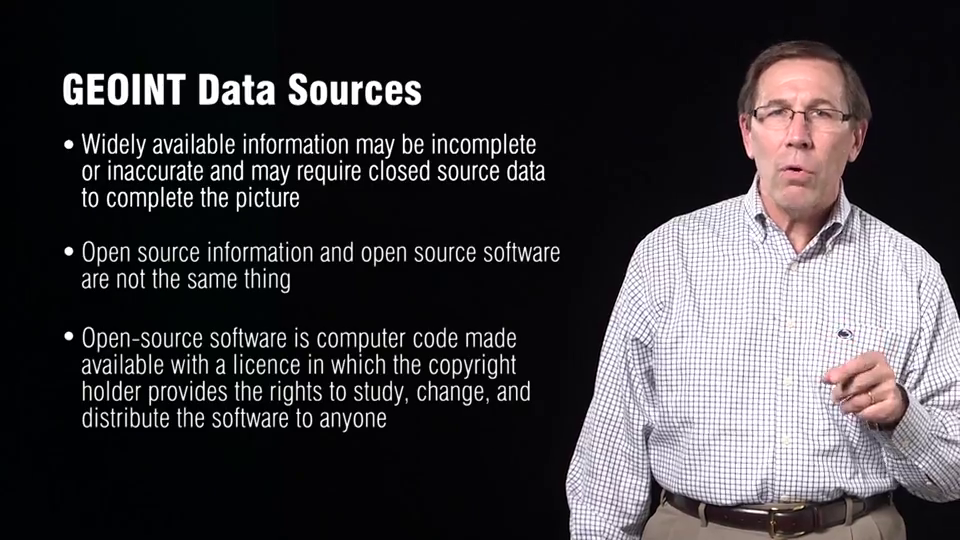
Week Three: GEOINT Data Sources.
Understand how GEOINT data is collected by a variety of methods including satellites, drones, crowdsourcing, and through social media.
Week Four: The GEOINT Tradecraft.
Apply the art and science of extracting meaning from GEOINT data to uncover and investigate relationships and patterns.
Week Five: Applying GEOINT Principles.
Use GEOINT principles to evaluate and transform raw data into descriptions, explanations, or judgments about a place.
also You can watch my other last: Coursera-posts
General
Complete name : 02_Lesson_1_-_Lecture_1.mp4
Format : MPEG-4
Format profile : Base Media
Codec ID : isom
File size : 27.2 MiB
Duration : 9mn 5s
Overall bit rate : 419 Kbps
Writing application : Lavf55.19.104
Video
ID : 1
Format : AVC
Format/Info : Advanced Video Codec
Format profile : Main@L3.1
Format settings, CABAC : Yes
Format settings, ReFrames : 4 frames
Codec ID : avc1
Codec ID/Info : Advanced Video Coding
Duration : 9mn 5s
Bit rate : 282 Kbps
Width : 960 pixels
Height : 540 pixels
Display aspect ratio : 16:9
Frame rate mode : Constant
Frame rate : 29.970 fps
Color space : YUV
Chroma subsampling : 4:2:0
Bit depth : 8 bits
Scan type : Progressive
Bits/(Pixel*Frame) : 0.018
Stream size : 18.4 MiB (67%)
Writing library : x264 core 138
Encoding settings : cabac=1 / ref=3 / deblock=1:0:0 / analyse=0x1:0x111 / me=hex / subme=7 / psy=1 / psy_rd=1.00:0.00 / mixed_ref=1 / me_range=16 / chroma_me=1 / trellis=1 / 8x8dct=0 / cqm=0 / deadzone=21,11 / fast_pskip=1 / chroma_qp_offset=-2 / threads=12 / lookahead_threads=2 / sliced_threads=0 / nr=0 / decimate=1 / interlaced=0 / bluray_compat=0 / constrained_intra=0 / bframes=3 / b_pyramid=2 / b_adapt=1 / b_bias=0 / direct=1 / weightb=1 / open_gop=0 / weightp=2 / keyint=250 / keyint_min=25 / scenecut=40 / intra_refresh=0 / rc_lookahead=40 / rc=crf / mbtree=1 / crf=28.0 / qcomp=0.60 / qpmin=0 / qpmax=69 / qpstep=4 / ip_ratio=1.40 / aq=1:1.00
Language : English
Audio
ID : 2
Format : AAC
Format/Info : Advanced Audio Codec
Format profile : LC
Codec ID : 40
Duration : 9mn 5s
Bit rate mode : Constant
Bit rate : 128 Kbps
Channel(s) : 2 channels
Channel positions : Front: L R
Sampling rate : 44.1 KHz
Compression mode : Lossy
Stream size : 8.32 MiB (31%)
Language : English
Screenshots
Coursera - Geospatial Intelligence & the Geospatial Revolution (2016)

Coursera - Geospatial Intelligence & the Geospatial Revolution (2016)
Coursera - Geospatial Intelligence & the Geospatial Revolution (2016)


Coursera - Geospatial Intelligence & the Geospatial Revolution (2016)

Coursera - Geospatial Intelligence & the Geospatial Revolution (2016)

Exclusive eLearning Videos ParRus-blog ← add to bookmarks

Coursera - Geospatial Intelligence & the Geospatial Revolution (2016)
